Massanutten Mountain Trails 100 Mile Run
You are here:
- MMT Home »
- Live Updates
Follow Your Runner
Splits and Results
Splits - runners' times of arrival at each aid station
Results - detailed results
Out of Race - Did not Start or Did not Finish
Mug Shots of Runners
Section Times - Historical Fastest/Average/Slowest times between each aid station
Runners - Up to date Solo and VHTRC membership
Leader Board
Runners are sorted by time of arrival at most distant aid station.
| Place | Name | A/S | Time | Status |
|---|
| 1 | Matthew Thompson | Finish | 23:07 | 19:07:59 |
| 2 | Jason Lantz | Finish | 0:35 | 20:35:25 |
| 3 | Scott Gregor | Finish | 1:42 | 21:42:45 |
| 4 | Pierre-Michel Arcand | Finish | 2:03 | 22:03:37 |
| 5 | Joey Cohen | Finish | 2:15 | 22:15:37 |
| 6 | Joel Noal | Finish | 2:45 | 22:45:31 |
| 7 | David Lantz | Finish | 2:51 | 22:51:59 |
| 8 | Patrick Heine | Finish | 3:28 | 23:28:24 |
| 9 | Ryan Quinnelly | Finish | 3:39 | 23:39:14 |
| 10 | Eric Harris | Finish | 3:41 | 23:41:35 |
| 11 | Denis Cook | Finish | 3:47 | 23:47:25 |
| 12 | Jesse Tubb | Finish | 4:11 | 24:11:46 |
| 13 | Kathleen Cusick | Finish | 4:27 | 24:27:24 |
| 14 | Martin Rouillard | Finish | 5:44 | 25:44:07 |
| 15 | Joshua Laker | Finish | 5:53 | 25:53:30 |
| 16 | Keith Knipling | Finish | 6:12 | 26:12:59 |
| 17 | Kelsey Allen | Finish | 6:17 | 26:17:15 |
| 18 | Wesley Hunt | Finish | 6:22 | 26:22:12 |
| 19 | Avery Frantz | Finish | 6:32 | 26:32:21 |
| 20 | Christopher Miller | Finish | 6:40 | 26:40:15 |
| 21 | Dustin Campion | Finish | 6:40 | 26:40:56 |
| 22 | Jesse Fuller | Finish | 6:42 | 26:42:59 |
| 23 | Kelly MacDonald | Finish | 6:44 | 26:44:48 |
| 24 | Patrick Kanold | Finish | 6:48 | 26:48:51 |
| 25 | Enrique Rubio | Finish | 7:14 | 27:14:14 |
| 26 | Brian Huffman | Finish | 7:19 | 27:19:58 |
| 27 | Rhoda Smoker | Finish | 7:23 | 27:23:17 |
| 28 | Ryan Nebel | Finish | 7:42 | 27:42:44 |
| 29 | John Lehmann | Finish | 7:47 | 27:47:34 |
| 30 | Matthew Smith | Finish | 7:50 | 27:50:54 |
| 31 | Dan Rogers | Finish | 7:56 | 27:56:39 |
| 32 | Matt Banning | Finish | 8:04 | 28:04:04 |
| 33 | Ryan Staggs | Finish | 8:09 | 28:09:17 |
| 34 | David Kennedy | Finish | 8:22 | 28:22:20 |
| 35 | Erick Kuhlmann | Finish | 8:23 | 28:23:39 |
| 36 | Tony McCormick | Finish | 8:38 | 28:38:51 |
| 37 | Erik Price | Finish | 8:49 | 28:49:41 |
| 38 | Aaron Shapiro | Finish | 8:52 | 28:52:27 |
| 39 | Vivien Taylor | Finish | 9:10 | 29:10:34 |
| 40 | David Peterman | Finish | 9:10 | 29:10:39 |
| 41 | Thad Will | Finish | 9:11 | 29:11:52 |
| 42 | Josh Howe | Finish | 9:16 | 29:16:30 |
| 43 | Brad Olzinski | Finish | 9:40 | 29:40:09 |
| 44 | Christopher Scarpitti | Finish | 10:10 | 30:10:54 |
| 45 | Andy Peterson | Finish | 10:12 | 30:12:24 |
| 46 | James Heun | Finish | 10:22 | 30:22:01 |
| 47 | Lyn Jones | Finish | 10:22 | 30:22:24 |
| 48 | Lisa Jones | Finish | 10:24 | 30:24:08 |
| 49 | David R. Brown | Finish | 10:28 | 30:28:55 |
| 50 | Frederic Giguere | Finish | 10:38 | 30:38:37 |
| 51 | Susan Donnelly | Finish | 10:46 | 30:46:56 |
| 52 | Doug Massengale | Finish | 10:48 | 30:48:37 |
| 53 | Arron Garrod | Finish | 10:52 | 30:52:50 |
| 54 | Mark Manny | Finish | 10:52 | 30:52:50 |
| 55 | Jim Roche | Finish | 11:02 | 31:02:56 |
| 56 | Kevin Dempsey | Finish | 11:07 | 31:07:06 |
| 57 | Jace Neuenschwander | Finish | 11:11 | 31:11:44 |
| 58 | Albert Cramer | Finish | 11:16 | 31:16:40 |
| 59 | David Glaser | Finish | 11:18 | 31:18:29 |
| 60 | Greg Trapp | Finish | 11:28 | 31:28:04 |
| 61 | George Teas | Finish | 11:32 | 31:32:10 |
| 62 | Kevin Clark | Finish | 11:32 | 31:32:50 |
| 63 | Joseph Pinter | Finish | 11:37 | 31:37:24 |
| 64 | Scott Waldrop | Finish | 11:39 | 31:39:15 |
| 65 | Serge Gosselin | Finish | 11:44 | 31:44:11 |
| 66 | Stephanie Dempsey | Finish | 11:47 | 31:47:00 |
| 67 | Sarka Petrickova | Finish | 11:47 | 31:47:00 |
| 68 | Steve Morneau | Finish | 11:57 | 31:57:53 |
| 69 | Patrice Godin | Finish | 11:58 | 31:58:00 |
| 70 | Patrick Lichy | Finish | 12:00 | 32:00:23 |
| 71 | Brett Lynch | Finish | 12:02 | 32:02:25 |
| 72 | Alvin Lee | Finish | 12:02 | 32:02:47 |
| 73 | Thomas Haine | Finish | 12:10 | 32:10:58 |
| 74 | Doug Schuch | Finish | 12:22 | 32:22:16 |
| 75 | Bert Salter | Finish | 12:37 | 32:37:43 |
| 76 | Don Knight | Finish | 12:40 | 32:40:05 |
| 77 | Brett Martin | Finish | 12:43 | 32:43:56 |
| 78 | James Miller | Finish | 12:50 | 32:50:09 |
| 79 | Lori Johnson | Finish | 13:04 | 33:04:25 |
| 80 | Mike Winston | Finish | 13:06 | 33:06:51 |
| 81 | Harry Mattison | Finish | 13:09 | 33:09:40 |
| 82 | Rhonda Stricklett | Finish | 13:09 | 33:09:59 |
| 83 | Chris Gellene | Finish | 13:12 | 33:12:23 |
| 84 | Jeff Pence | Finish | 13:22 | 33:22:59 |
| 85 | Jason Long | Finish | 13:28 | 33:28:58 |
| 86 | Kevin Mullen | Finish | 13:30 | 33:30:08 |
| 87 | Justin Peake | Finish | 13:37 | 33:37:37 |
| 88 | Jack Sayles | Finish | 13:42 | 33:42:08 |
| 89 | Will Robens | Finish | 13:49 | 33:49:15 |
| 90 | Eric McGlinchey | Finish | 13:52 | 33:52:24 |
| 91 | Robert Cawood | Finish | 13:53 | 33:53:34 |
| 92 | Adam Farley | Finish | 13:58 | 33:58:24 |
| 93 | Pascal Surprenant | Finish | 14:01 | 34:01:11 |
| 94 | Peter Daly | Finish | 14:01 | 34:01:54 |
| 95 | Kevin Cavasos | Finish | 14:03 | 34:03:04 |
| 96 | Kumiko Hart | Finish | 14:17 | 34:17:54 |
| 97 | Adam Korona | Finish | 14:18 | 34:18:32 |
| 98 | Michael Walcott | Finish | 14:25 | 34:25:12 |
| 99 | Larry Tumblin | Finish | 14:25 | 34:25:31 |
| 100 | Magdalena Casper-Shipp | Finish | 14:29 | 34:29:54 |
| 101 | Mandy Pierce | Finish | 14:30 | 34:30:20 |
| 102 | Roger Jensen | Finish | 14:31 | 34:31:19 |
| 103 | Jamie Greenawalt | Finish | 14:37 | 34:37:38 |
| 104 | Larry Huffman | Finish | 14:37 | 34:37:38 |
| 105 | Samantha Pitts-Kiefer | Finish | 14:39 | 34:39:58 |
| 106 | Philippe Cavatore | Finish | 14:41 | 34:41:20 |
| 107 | Sergey Boldyrev | Finish | 14:42 | 34:42:35 |
| 108 | Olivier Jacqueau | Finish | 14:43 | 34:43:10 |
| 109 | Levi Rizk | Finish | 14:43 | 34:43:10 |
| 110 | Joshua Wynn | Finish | 14:54 | 34:54:50 |
| 111 | Steve Bodnar | Finish | 14:59 | 34:59:03 |
| 112 | Roy Heger | Finish | 15:00 | 35:00:15 |
| 113 | John W. Taylor | Finish | 15:15 | 35:15:44 |
| 114 | Timmy Aquino | Finish | 15:24 | 35:24:02 |
| 115 | Philip Pagdanganan | Finish | 15:24 | 35:24:02 |
| 116 | Gregg Calhoon | Finish | 15:36 | 35:36:41 |
| 117 | Jeff Mandrell | Finish | 15:43 | 35:43:16 |
| 118 | Marvin Leventer | Finish | 15:43 | 35:43:45 |
| 119 | Linda Trinh | Finish | 15:46 | 35:46:06 |
| 120 | Ray Miraflor | Finish | 15:46 | 35:46:27 |
| 121 | Sirisha Golla | Finish | 15:46 | 35:46:35 |
| 122 | Vincent Swendsen | Finish | 15:52 | 35:52:16 |
| 123 | Ernesto Casarez | Finish | 15:53 | 35:53:35 |
| 124 | Leonard Martin | Finish | 15:57 | 35:57:26 |
| 125 | Debbie Daughtry | Finish | 15:58 | 35:58:04 |
| 126 | Tony Escobar | Finish | 15:59 | 35:59:08 |
| 127 | Matthew Vahey | Finish | 16:08 | 36:08:55 |
| 128 | Jennifer Hotchkiss | Finish | 16:29 | 36:29:04 |
| 129 | Khalid Miah | 15 | 13:55 | dnf |
| 130 | Pierre Lequient | 14 | 3:00 | dnf |
| 131 | Gary Knipling | 14 | 10:13 | dnf |
| 132 | Brian Brown | 14 | 10:35 | dnf |
| 133 | Tracy Cooley | 14 | 10:49 | dnf |
| 134 | Sarah Harry | 14 | 12:10 | dnf |
| 135 | James Blandford | 12 | 21:48 | dnf |
| 136 | David Peppelman | 12 | 23:44 | dnf |
| 137 | Russell Dresher | 12 | 0:47 | dnf |
| 138 | Jeffery Hayes | 12 | 1:01 | dnf |
| 139 | Joan Roch | 12 | 1:21 | dnf |
| 140 | Gary Long | 12 | 2:56 | dnf |
| 141 | Gilles Poulin | 12 | 4:22 | dnf |
| 142 | Shawn Krause | 12 | 4:25 | dnf |
| 143 | Nicole Ponte | 12 | 5:12 | dnf |
| 144 | Alejandro Zapata | 12 | 6:10 | dnf |
| 145 | Brad Bansner | 12 | 6:12 | dnf |
| 146 | Thomas Chobot | 12 | 7:18 | dnf |
| 147 | Michael Johnson | 12 | 7:37 | dnf |
| 148 | Justin Hersh | 11 | 21:46 | dnf |
| 149 | Joanne Fenninger | 11 | 23:27 | dnf |
| 150 | Lisa Johnston | 11 | 2:19 | dnf |
| 151 | Ryan Vandenberg | 11 | 2:53 | dnf |
| 152 | Justin Faul | 10 | 19:06 | dnf |
| 153 | Martin Bherer | 10 | 19:08 | dnf |
| 154 | Adam Dyas | 10 | 19:32 | dnf |
| 155 | Philip Yeager | 10 | 19:45 | dnf |
| 156 | Edward Wang | 10 | 20:41 | dnf |
| 157 | Kelly Shaer | 10 | 22:36 | dnf |
| 158 | Jesse Parker | 10 | 22:38 | dnf |
| 159 | Scott Lee | 10 | 22:50 | dnf |
| 160 | Vincent Gauthier | 10 | 22:51 | dnf |
| 161 | Ryan Stuart | 10 | 23:00 | dnf |
| 162 | Adeline Ntam | 10 | 23:46 | dnf |
| 163 | Adam McGinnis | 10 | 23:54 | dnf |
| 164 | Mike Maher | 10 | 0:01 | dnf |
| 165 | Hompeng Komthirath | 10 | 0:23 | dnf |
| 166 | Ray Bovaird | 10 | 0:26 | dnf |
| 167 | Giles Gregory | 10 | 0:58 | dnf |
| 168 | Jayme Dubinsky | 10 | 2:10 | dnf |
| 169 | Sarah Curtis | 10 | 3:05 | dnf |
| 170 | Alexandre Benoit | 9 | 19:39 | dnf |
| 171 | John Correiro | 9 | 20:23 | dnf |
| 172 | Andrew Arbuckle | 9 | 21:04 | dnf |
| 173 | Sam Coyner | 9 | 21:16 | dnf |
| 174 | K Mike Edwards | 9 | 21:20 | dnf |
| 175 | Shelly Cable | 9 | 21:22 | dnf |
| 176 | Charles Leonard | 9 | 21:22 | dnf |
| 177 | John Hodge | 9 | 22:00 | dnf |
| 178 | Cindylee Torres | 9 | 22:00 | dnf |
| 179 | Joyce Fendley | 8 | 19:55 | dnf |
| 180 | Judith Weber | 8 | 20:25 | dnf |
| 181 | Bill Thompson | 7 | 16:51 | dnf |
| 182 | Tim ODonnell | 6 | 10:55 | dnf |
| 183 | Allan Holtz | 6 | 16:10 | dnf |
| 184 | Bob Anderson | 6 | 16:15 | dnf |
| 185 | Carole Williamson | 6 | 16:18 | dnf |
| 186 | Siobhan Leonardis | 5 | 11:40 | dnf |
| 187 | Sherry Meador | 5 | 14:03 | dnf |
| 188 | Dan Aghdam | 4 | 10:34 | dnf |
| 189 | Katie Burke | 3 | 10:30 | dnf |
| 190 | Jim Ryan | 2 | 08:00 | dnf |
What's the Weather Like?
 Don't forget the U.S. Weather Service page. It takes some getting used to, but it is very helpful.
See for Yourself
This is for those who want to see it. During the daylight hours, you can see what the weather is. Sort of. Is it overcast, sunny, or raining?
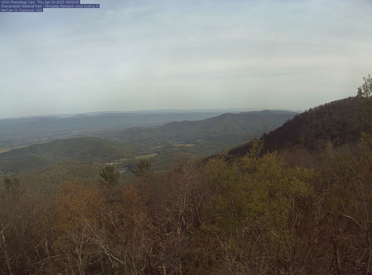
View from the Blue Ridge: You can see a live view of the Massanutten Mountains from the Mountain View Web Cam in the Shenandoah National Park. (More about the camera.) The camera is not in the Massanuttens, but it is pointing west toward them. The most distant ridge is in West Virginia. The two ridges in front of that are the Massanuttens. If you look closely, you will see Kennedy Peak and Edinburg Gap. The start/finish is between those two landmarks. It is not visible. This camera is above 3,000 feet. The Massanuttens are 2,000 feet. Fog that the camera sees may not be replicated on the course. Explanation of the camera's image: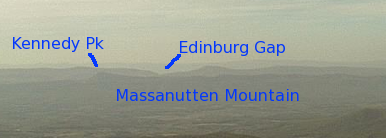
MMT 2018 Live
Start: 4:00 a.m., May 19, 2018
| Fort Valley Time Now | Strict Standards: mktime(): You should be using the time() function instead in /home/vhtrc/public_html/mmtlive/index.php on line 371 03:35:51 |
| Time Since Start | Strict Standards: mktime(): You should be using the time() function instead in /home/vhtrc/public_html/mmtlive/index.php on line 380 not race day |
| Sunrise/set on May 19 | 5:58/20:22 |
Updates
Kathleen Cusick Finishes Her 10th MMT and has Fourth Win; Matthew Thompson Wins Male Title!
Run Info
The Updates
Monday 09:49 Initial results here.
Sunday 20:42 There were 126 official finishers. We will have full results, photos, and reports up soon.
Sunday 06:27 Kathleen Cusick's time of 24:27:24 led to her fourth straight MMT win. She has 10 consecutive finishes.
Sunday 06:20
Saturday 23:16 Matthew Thompson wins the 2018 Massanutten Mountain Trails 100 in a time of 19:07:59. This was is first MMT.
Saturday 21:45 The weather is definitely better. Matthew Thompson is roughly on the pace of last year's winner, who finished at about 11 p.m. Stay tuned!
Saturday 12:35 Weather is improving. Temp in the mid-60s. Not much rain--only minor drizzle. It is significantly brighter here now.
Saturday 09:46 Times are coming in from up to aid station four. We don't always receive them in a logical fashion.
Saturday 08:58 Pierre-Michel Arcand and Patrick Heine led the field into the first real aid station, Edinburg Gap. Kathleen Cusick was first woman. There was one drop. There are now 189 runners in the race.
Saturday 04:51 There are 190 runners in the race.
Saturday 04:23 They started in light, but steady rain. There was about an inch of rain overnight. It's 58 degrees. Will have the Did Not Start list up soon.
Here are a points you should remember:
- If you drop, return your bib number to the aid station captain or other official. The only way you should leave with your bib number is if you finished the race.
- Nothing on this Web site will be available at the event. If you want something, print it out and bring it. If you need the crew instructions, print them for yourself. Crew Instructions
- The Camp is not near civilization. The nearest food, coffee, 7 Eleven, etc. is at least an hour round trip from the Camp. Also, there is no cell phone access at the Camp. (To get cell phone access, drive 1.7 miles east on Route 675. You should get coverage at the top of the hill.) If your carrier is Sprint, you might get service.
Our Plans
We will be radio headquaters near, but not at, the finish line. We may have Internet access where we will be.
We hope to have our first update by noon on Saturday. That should confirm who has started and should have the results from the first major aid station at Edinburg Gap, 12.1 miles. Then we will try to upload as often as we can.
We have learned there is much room for error. Most of our information will be accurate. Some will not be.
If you have a question or want to understand the process better, check out the frequently asked questions.
If you are interested in the updates, let us know. Late at night, it helps to know someone is out there! You can reach us at anstr@vhtrc.org.
by Anstr Davidson
E-Mail: anstr@vhtrc.org