Information
Details
The run will start at 7:00 AM, and you will have 16 hours to complete the course (11:00 PM cutoff). There will an intermediate cutoff as well. See the results from last year to get a feel for how long the run might take you.
Route
The route of the run is shown below.
SMUT Run GPS track
GPS track of the SMUT Run with locations of aid stations shown.
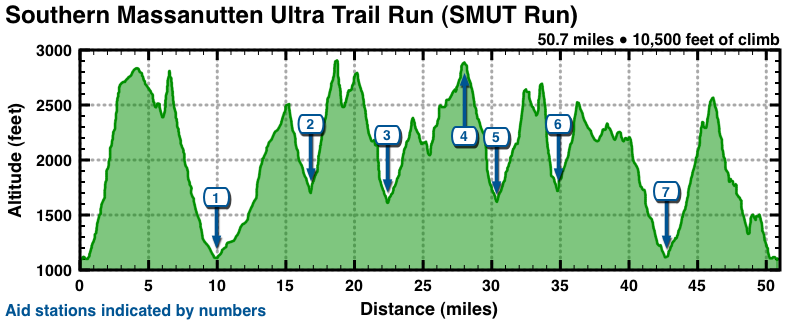
Here is the corresponding altitude profile, showing the locations of the aid stations.
Click to enlarge
Altitude profile of the SMUT 50
Altitude profile of the SMUT 50. Locations of the seven aid stations are indicated.
Aid stations
There are a total of seven aid locations, three of which you will visit twice. You will be able to have one drop bag that will be at Fridley Gap (AS 2 and 6, miles 16.7 and 35.2). There is one strict intermediate cutoff: you must pass through AS 5 (Runkles Gap, mile 22.6) by 2:00 PM (7:00 running time).
| Aid station | Mile | Elevation (feet) | ETA (first / last runner) | |
|---|---|---|---|---|
| Finish | 51.8 | 1,100 | 5:00pm / 11:00pm | |
| 1. | Catherine Furnace | 10.0 | 1,120 | 8:45am / 10:00am |
| 2. | Fridley Gap | 16.7 | 1,650 | 10:00am / 12:15pm |
| 3. | Runkles Gap | 22.6 | 1,585 | 11:00am / 2:30pm |
| 4. | Massanutten Vista | 26.4 | 2,480 | 11:45am / 3:45pm |
| 5. | Runkles Gap | 30.7 | 1,585 | 12:15pm / 4:00pm |
| 6. | Fridley Gap | 35.2 | 1,650 | 1:30pm / 5:30pm |
| 7. | Catherine Furnace | 43.0 | 1,120 | 2:30pm / 8:00pm |
Although we are doing this fatass style you will be “assigned” to bring a food/drink item for the community aid.
Directions to the start at the Rt 211 trailhead:
The location of the start/finish is here on Google Maps. Enter in your starting address to generate customized driving directions. There are three general routes you can take:
- I-66 West to Rt 340 South to Rt 211 West
- From the DC Beltway (I-495), take 1-66 West approx. 60 miles to US 340 south (Exit 6, - the second Front Royal exit). Follow US 340 south, turning onto Rt. 211 West just prior to the town of Luray. The Rt 211 East Parking Lot is on the left.
- I-66 West to I-81 South to Rt 211 East
- From the DC Beltway (I-495), take I-66 West past Front Royal, VA, to I-81 southbound to New Market, VA. From New Market, take Rt 211 Eastbound. After crossing over Massanutten Mountain and passing the Forest Service Visitor’s Center, the Rt 211 East Parking Lot is on the right.
- I-66 West to Rt 29 South to Rt 211 West
- From the DC Beltway (I-495), take I-66 West for approximately 20 miles to exit 43B for Rt 29 South. At Warrenton, take Rt 211 West. The Rt 211 East Parking Lot is on the left, approximately 50 miles West of Warrenton.
Volunteers
We will need volunteer support to man aid stations. If you aren't going to run, please consider volunteering.
Resources
You will need the Potomac Appalachian Trail Club's (PATC) Map H — Trails in Massanutten Mountain, South Half, which is available online from the PATC Website or at area outfitters such as REI.
Last modified: Oct 18, 2010