Coyote Fourplay 2005
By Anstr Davidson
Jump to Photos
C4P VHTRC Home | Howard's C4P Web site
The Coyote Fourplay is not your average run. It is, well, it is a Chris Scott creation. So that should tell you to expect the unexpected.
![]() The 2005 C4P was preceded by drenching rains in southern California. The local TV news, usually dominated by freeway chases and bizarre California politics, was now "all rain, all the time." The TV choppers diverted from the police chases to hover over swimming pools that were sliding down hills. Newscasters were using terms like "red tagged" and "yellow tagged" as if everyone knew what they meant. (It seems that if the officials "red tag" your house, you have to move out to watch it slide down the hill.) L.A. was proud that it had more rain for the year than Seattle. Everyone wanted the rain to stop, but also wanted to break the record for annual rainfall. The rain even made people forget that the Lakers suck this year.
The 2005 C4P was preceded by drenching rains in southern California. The local TV news, usually dominated by freeway chases and bizarre California politics, was now "all rain, all the time." The TV choppers diverted from the police chases to hover over swimming pools that were sliding down hills. Newscasters were using terms like "red tagged" and "yellow tagged" as if everyone knew what they meant. (It seems that if the officials "red tag" your house, you have to move out to watch it slide down the hill.) L.A. was proud that it had more rain for the year than Seattle. Everyone wanted the rain to stop, but also wanted to break the record for annual rainfall. The rain even made people forget that the Lakers suck this year.
 C4P occurs in the middle of what passes for a rainy season in southern California. The hills are brown except for the month or so after the rains. C4P is scheduled intentionally for the season where the song lyrics, "it never rains in southern California" are wrong. It never does rain from May to September. (The L.A. Dodgers went for years after their move from Brooklyn before they finally had a game rained out.) But February can be wet and cold.
"Cold" is a relative term in southern California. Along the coast, "cold" never equals below freezing. It rarely equals a temperature below 40. But there is a special kind of bone-chilling cold that the coast can impart. Having wet air blown in your face while wearing thin cotton clothing can produce cold that is memorable.
Thus, many were fearing the 2005 C4P. They expected horrendous conditions. Some, like this reporter, forgot to pack many of the southern California staples like sun screen, wide hats, and white cotton shirts.
"Southern" California
 Ventura County, where C4P is located, is not really part of the "southern California" of beaches, deserts, and freeways. Once you leave the San Fernando Valley on Highway 101, you enter a coastal wonderland that is no longer the noisy, smoggy L.A. but not yet the northern sophistication of the "Bay Area." The region had a low profile before Ronald Reagan went home to his ranch, Michael Jackson entertained boys, and Sideways. Unfortunately, its secret is out and development is rampant. Oxnard, itself, seems to be constantly under construction.
The real gems in this region are the inland areas like Ojai (scene of the longest C4P day) and the Santa Ynez Valley (of Sideways fame). These valleys have weather that is nearly perfect -- drier and warmer than on the coast, but still mild by any other standards.
Morro Bay
 The weather actually broke on the day before the first C4P day. I spent that day in Morro Bay visiting a college friend. Among the sights of this central coastal city was Piedras Blancas, a beach near San Simeon that is a breeding and birthing ground for elephant seals. (San Simeon is more famously known for the Hearst Castle.) The "baby" seals were about a month old, but didn't look very small. Most of their mothers had gone to sea, and they were left to fend for themselves. On the way back, we watched the sun set over the Pacific from Morro Rock.
Through Wine Country
When I heard that Sideways is a movie about the wine country, I assumed it was about the Napa Valley. Santa Barbara County was not wine county in the old days. It sure is today. Below Santa Maria, you pass miles and miles of vineyards along Highway 101. I enter the Santa Ynez Valley and drive through Los Olivos toward Lake Cachuma. The last time I was at Lake Cachuma was with my grandfather in about 1960.
 My grandfather and I visited Lake Cachuma not because it was beautiful or because we wanted to fish or boat. We visited it because it was water. Water is a big issue in California and was always the center of conversation in my family. One needed water to irrigate the citrus trees. Without water, there would be no Los Angeles as we know it today. Lake Cachuma was a big deal for Santa Barbara County's water supply, and my grandfather and I had to visit it to look with approval. I stop and look again, realizing that I had stood at the same spot many years ago with a man who was then only a bit older than I am now.
They Leave the Light On
At the original one of these things, the Mugu 50-50, I stayed at the Motel 6 in Camarillo. (That does not rhyme with "Brillo" pad.) I have stayed there ever since. The Motel 6 has become a cheap, known quantity to me. It is a bit further to Ojai, but much closer to Point Mugu State Park, the site of C4P days one, three, and four. So I check in, and then drive over to the start of the C4P "teaser."
The Teaser
 Here we are again. All the old regulars with some newbies thrown in. We get our talisman from akabill and our registrant's bag from Howard. The C4P registrant's bag is one big mockery of the Western $tates 100. Your bag will contain anything that Chris has been able to "obtain" over the last year. This year's bag included the following goodies:
- A kazoo
- Various stickers ("Girls Rule," "No good deed goes unpunished," etc.)
- Business cards from wherever
- Brochures for tours of Paris in Italian, German, Dutch, Spanish, French, and English
- Two C4P water bottles (brining my collection of such bottles to at least 500)
- A flyer for the Museum of Sex in New York City. (As an added bonus, Zoe gives us energetic descriptions of a visit to the museum.)
- About five each Patagonia and Montrail stickers
- A cool watch cap
- A technical t-shirt
- A very cool fleece jacket with a zipper all the way up (no pullover)
In the past, C4P bags have had Madonna CDs, vibrators, soap and shampoo stolen from various hotels (your tax dollars have sent Chris on many a boondoggle on "official" travel), and a baggie of beach sand. The smart C4P entrant always comes with room in his suitcase. You need it.
The teaser run itself is a wonderful event. It is just an up and down. The up goes by the waterfall that is normally a trickle but today is a real shower. The down is the famous and wonderful Ray Miller Trail. Ray Miller is a smooth, single track steady downhill with views of the beach, the ocean, and the Channel Islands. You can see the parking lot from the top. The end is always in sight from the Ray Miller Trail.
The evening's festivities are at a brew pub (BJ's). Chris gives his welcome/briefing/roast/etc. It is not in English but everyone enjoys it anyway. (Chris speaks a strange language that is a product of his indoctrination at the Air Force Academy, his sharp mind, and the consumption of a bit too much alcohol.) Chris explains the 43rd change in the Ojai course that we will run tomorrow. The rain has caused all sorts of trouble there and many alternate courses have been planned. We finally get the last version.
Ojai
The smell of eucalyptus trees greets us as we enter Ojai and the start of the 50 miler on day two of C4P. This 50 is a real bear. I have never done it. Even if I could do it, I wouldn't as it blows the entire day. It is a long seven miles to the top of Nordhoff Peak at 4,485 feet. And then the fun really begins.
 Today, the weather is still good, but it is a bit hazy. The views are not as good as usual. You can usually see not only the Channel Islands from up here, but also the mountains of the next days' runs in Point Mugu. We can see the Ojai Valley with its citrus orchards. It reminds me of what the San Fernando Valley of my youth.
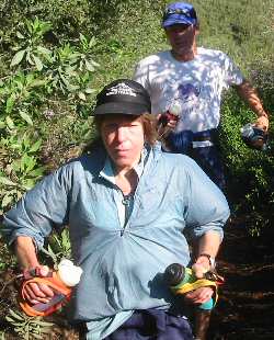
On this run, there are courses all over everywhere. The "long" folks go a different way from the short and medium folks. The result is that I am walking up the hill to Gridley Saddle when the top guns are running down toward me. It is a fairly impressive cast of characters including a husband-wife team from northern California that has not been here before (picture right). The VHTRC'ers are doing well. Aaron Schwartzbard is way up there as is Scott Mills. Sue Johnston and Joe Clapper are a little further back.
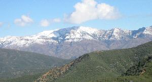 When I get to the top of the hill, I decide that I am not feeling well and should go back. The course I should have taken goes along the ridge -- flat as looked at from a distance but definitely up and down if you run it. I will miss running into the snow this year. Actually, the snow level is relatively high. This is one of the few years I will not be in some snow at C4P.
("Snow level" does not mean the depth of the snow. It means the elevation on the mountain at which the snow stops. Snow does not occur where you live in southern California. You visit it. The "snow level" is the elevation up to which you have to drive to visit the snow.)
I leave the hospitality of the Gridley top aid station and go back down the hill. Except you can only go down after about another mile of up. At the very top, I take the detour to Nordhoff Peak. The view from here is fantastic. It makes the climb worth it.
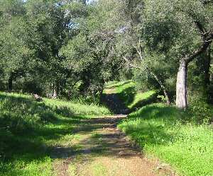 The way down is long. At first it is single track trail but then, becomes an old road. At the bottom, everything is green and the live oaks are prominent. It is like the Shire. I expect to see Bilbo Baggins at the next turn. There are washouts and plenty of mud. We have to cross a roaring stream. Finally, I make it back to the start/finish where it is warm, sunny and there are "refreshments."
Tonight will be the "entertainment." I have been running all day by myself and have had time to come up with a routine. Since I have stopped early, I will have plenty of time to prepare. Will it go over all right, or will it bomb like the routine of a certain VHTRC member did last year? We will see.
The Entertainment
Chris's great plan is that everyone will display his wonderful talents to the crowd on Talent Night. Unfortunately, there is not that much talent to go around and, if there were, no one would get to bed before midnight. There are, however, about four or five individuals and the same number of groups who, based on a mixture of talent and lack of pride, stand up to entertain their peers.
The talent boils down to (1) musical numbers some with funny lyrics, (2) stand-up comedy, and (3) a mixture of the two. Highlights were the Kazoo/bag pipe duo of Bill and Kim and the Musical Chairs for Monks performed by the Ridgecrest crowd enhanced by the Colorado crowd.
My contribution was an advertisement for the follow-on event from the Coyote Fourplay -- the Coyote Ultimate Act. This event will be held on trails in New York City, this month's home of Chris Scott, so it will be called the "Coyote Ultimate New york Trail." At least it didn't bomb. (There is already a prototype race t-shirt. Anyone want it? You can't wear it in public.)
Day Three
The Day Three run is probably the best. But due to medical reasons (I was dying from a cold), I was a DNS. I understand from reliable sources that at least two VHTRC'ers got lost. Getting lost is easy to do. You are supposed to follow a C4P veteran, but vets often don't know the course any better than you do. The good news is that all the trails eventually lead to the same place and Chris will give you credit for the distance anyway. You just might go without aid for awhile.
Bowling
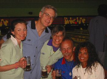 I get out of my death bed for bowling night. Bowling night may be one of the best ways to understand C4P. You are doing four days of tough running and you spend a night bowling? Huh? Well, what else would you do?
Last year's ringer, Jeff Washburn, sort of bombed this year. He didn't even beat 200. (Last year, Jeff had a perfect game going into the ninth frame.) Our team, Team Furbutts (or something like that), was competitive since two of us actually broke 130. The teams were put together by Chris. You can tell that Chris likes me since he put three lovely women on my team. He doesn't like me that much, however, he put Stan on the team to share the wealth.
After our bowling triumph, we repair to the bar for the evenings awards, razing, etc. In a typical Chris move, I receive a cook's hat from In-N-Out Burger. (In-N-Out Burger is a southern California institution. You can walk up to it, but no one does. This is southern California. You drive through it in your SUV.)
Anyway, Chris had obviously sweet-talked or stolen himself into possession of two cook's hats that say, "In-N-Out Burger." Or they previously said that. After some white tape covered the "B" and the "R," they now say, "In-N-Out Urge." Yup, that's C4P all right.
The Final Day
 So soon, it is the last day. Time for the 30 miler back in Point Mugu State Park. My cold is better and I can keep up with people who ran hard the day before while I was in the Motel 6 flu ward. I end up running most of the day with Laura DeWald and Colleen Dulin. We do the "medium" course. We cut out about eight miles and Chris gives us 22.
The day starts with a long pull up the Ray Miller Trail. Even the heavy weights walk a lot of this. They could run, you could run, but at this point, walking feels good -- at first at least.
 After you climb up, you go back down to Sycamore Canyon and up to the entrance of Serrano Valley. You have to cross a stream about 400 times to get into the valley. Normally, this stream is a mere trickle. Today, however, it is roaring. Every crossing is ankle deep. You get numb to it.
The reward for all of this stream crossing is the beautiful Serrano Valley. Serrano is a big, open field. Deep green at this time of year, the valley is peaceful and private yet within miles of the rest of teaming southern California. Laura notes the same image that others have before her -- it's like the first scene of The Sound of Music where Julie Andrews bursts into song on the grassy mountain top.
After the valley, we come upon the Sook and Maria aid station. I have a special tradition here. The trail comes in high above the aid station and then bends around. The high perch above the aid station just begs you to ... well, moon the aid station. So I do. (I will not reveal if anyone else joined in.) Unfortunately, Maria was not there this year to enjoy the view.
 The last part of the course is highlighted by Mugu Peak. A short but tough climb to the top (1,266 feet). From Mugu, you get a great view of the ocean, the islands, and the park. We take our pictures and go on to the finish.
The way down from Mugu Peak goes through the best places for wild flowers. It looks as if we are too late. They are not that good. There had been rain a month earlier and, perhaps, the flowers had already been out. We did see plenty of California poppies and wonderful poison oak.
From the top of the Ray Miller Trail, we can see islands. One is likely San Nicholas, some sixty miles out. The other is probably Catalina. One judges visibility at the beach by which islands he can see. "It was a clear day, you could see Catalina."
We run down the trail for the last time and finish. We are welcomed with food, drink, and good fellowship. Chris, Howard, and the Jaboys have put on another great C4P.
Epilogue
I remember what it is like to live here when I suggest to Scott Mills how he should drive home. "Take the 101 to 405, no, probably the 101 to Pasadena and the Foothill Freeway to 15, no, 101 to Hollywood to the 5, ..." He asks me why I keep changing my mind. I realize that you always change your mind. There is never just one way to go. Like a nimble running back, you change direction when necessary as you flow through the LA freeways at 70+ mph. Ah, the good old days. (It is not like if you want to go to Richmond the only reasonable way is I-95.)
I fly home to snow.
Anstr Davidson
March 2005
Photo Collages: Morro Bay | On the Gridley Trail | Top of Gridley | Down to Ojai | Bowling | Last Day Begins | Water | Serrano Valley | Last Day Ends | Flora
Virginia Happy Trails Running Club
Home | News | Events | About the VHTRC | Members Only | Features
Bull Run Run 50 | Massanutten Mt. Trails 100 | Training Runs | Links
Feedback