Quad State Quad Buster
Tentative Run Date: October 17, 2020
NEW 10/2019 - I'm looking specifically for volunteers who have vehicles with larger capacity seating to transport runners to the start. If you have a larger SUV with thrid row seating and a van/minivan and would be willing to help transport runners to the start, please let me know!
Read this entire page before entering.
Entry is open for VHTRC members only and per qualifications/experience listed below. Keep reading for entry info.
FINAL INSTRUCTIONS AND AID ASSIGNMENTS WILL BE SENT OUT TO ENTRANTS AND VOLUNTEERS ON THURSDAY EVENING, 10/15/2019
 The concept is simple. The run itself certainly is not: Start in PA, just north of the MD line, and run south in four states along, except for the end, the Appalachian Trail (PA->MD->WVa->VA). Total distance: long. Seems longer than it is. Your time/effort will be similar to that of a tough 50 miler.
This is a run with risks. Runners are responsible for their own health, safety and well-being. We do not provide medical support or care before, during or after the run. No doctors, nurses, or emergency medical technicians are available along the course, at any aid station, or at the finish. In case of an emergency, we will endeavor to get local emergency personnel to an injured runner as soon as possible but you are responsible for the cost of any emergency services that you might require. Possible issues include, but are not limited to: scrapes, sprains, bruises, cuts requireing stitches, bee stings, asthma attacks, broken bones, head trauma, dehydration, hypo- and hyper-thermia. Please be careful out there and most of all, come perpared with your training, gear and mentally. As is almost always the case, you are your own best advocate: a full charged cell phone, a map and awareness of where you are currently will go a long way!
This is a training run, not an event. There is no entry fee. We will support you and keep track of you in the name of safety but there is no keeping score; just friends supporting friends enjoying some trails and the outdoors.
Volunteers are needed!
- Transport to start: Need min 3 (maybe more if there are more runners?) larger sized vehicles are best but hey, we'll take whatever we can get! (Approx time needed - 5am-8am) May need more or less depending on field size and sizes of vehicles available.
- AS #1 and #3: Need min 1 person, 2 is better (8:30am-3pm) Will work aid station #1 and then pack up and move and oversee aid station #3.
- AS #2 and #5: Need min 1 person, 2 is better (10am-6pm) Will work aid station #2 and then pack up and move and oversee aid station #5.
- Finish: Need min 1, 2 is better (3pm-9pm); will provide general help and shuttle finishers from the finish back to the Weverton lot.
The above is an ideal breakdown of the work but may not suit your schedule/plans -- no worry, any help at all would be appreciated, just let me know.
If you can help, contact Bur. Please put QSQB in the subject line.
2019 volunteers:
Mike Bur (shuttle to start=5/6)
Alan Gowen (shuttle to start=7); Capt AS 2 & 5
Tom Simonds (shuttle to start=4); AS 1 & 3
Bruce Tweedie AS 1 & 3
Paul Crickard AS 2, 3 and 5
William Fallier AS 3 & 5
Anzhela Knyazeva AS 5
Deborah Marcus AS 5 finish shuttle
Catherine Howard AS 2, 3, 5
Total shuttle capacity= 16 (as of 10/7/2019)
Run description/background:
This is not a beginner level run.
Re-read that first sentence again, it's important and can't be understated. Experience running on tough trails for 50+ miles is required.
The run is very much old school in its philosophy and approach. If you don't have the mindset and mentailty of being by yourself on the trail for extended periods, solving your own problems, reading/following a map, figuring out how to self extract if needed, etc, then you're not going to do well here.
If I don't know you or you don't have some sort of verifiable resume/CV on athlinks.com or realendurance.com, this run just isn't going to be a good fit for you this year I need to know/understand the ultra/trail experience/history of everyone toeing the line at QSQB. But, we could always use more volunteers which could allow you to get a run in on the trail on your own outside your volunteer slot. Email me if you have any questions about these requirements. Participants will also be limited based on the number of volunteers I can get to commit for that day. Runners who have significant others or friends that can drive and therefore shuttle other runners will get entry priority. Runners who have finished in previous years also get priority. Having said that, we've never had to turn away someong due to capacity.
You will be allowed one reasonable sized drop bag labeled with your name that you will see twice: at Aid Station #2 and again at #5. BAGS only, no boxes, hard shell luggage or anything else solid, they just don't pack well and quite frankly are a burden to the volunteers as well as just an overall PIA to deal with. Drop bags should also not be trash bags. Trash goes in trash bags and I'm easily confused. Don't risk it. There will be aid at four locations, plus self serve water at one (see below). You will also be assigned an item(s) to bring to contribute to the community aid.
It's the AT, it's blazed white, how hard could it be to follow?
That notwithstanding, PATC map 5&6 [that's only one piece of paper] is required gear. The last couple of miles leave the AT and are on a blue-blazed side trail. This map is available from the PATC store. Don't wait to try and get this last minute since it usually has to be ordered/shipped. REI may have it in stock.
A working cell phone with a fully charged battery is also required gear. When you register, list your cell phone number - you may need to contact me or I may need to contact you during the event. Listing your home number doesn't help anyone. Not listing a number means NO ENTRY
You will also need a light in your drop bag -- except for the very fast, many will finish in the dark. Be prepared.
We will try our best to support everyone on this run. However, be prepared -- mentally, physically and with your gear. If you are fast, you could very well out run the aid and/or your drop bag. Ask Keith Knipling. Ask Sean Andrish when he set the course record. If you are moving slow, having a bad day and/or get lost, you may arrive at and aid location to find the station has already packed up and moved forward. Ask Joe Hanle. None of these guys whined about their situations. If you find yourself as an outlier at either of these ends, be prepared to solve your own problems. A working phone and an extra layer(if it's cold/rainy) can go a long way here.
In the morning, we will meet at the Weverton parking lot. We will then cram as many people into as few cars as possible and shuttle everyone to the start at Pen Mar. Get to the Weverton parking lot by 5:45 a.m. at the latest as we will be leaving at 6 a.m. sharp and shoot for an 7 am start -- the days are getting shorter and we will want to maximize the amount of usable daylight available.
The run starts at Pen Mar(actually at the road crossing just north, in PA) at 7ish a.m. Aid will be at five locations:
- Wolfsville Rd (9 mi) - map
- Rt70/Rt40 (17 mi) - map [cutoff: 12:30]
- Rt 40alt (22 mi) - map [cutoff: 1:45 those arriving after 1:00 should have light when they leave]
- Crampton Gap/Gapland Rd.(self serve water only) (29 mi) - map
- Weverton (36 mi) - map [hard cutoff: 5:30 (this is where we will also be meeting for the car pool in the morning)]
To keep things moving, there will be two "soft" cutoffs and one hard cutoff. AS2 (17 mi) at 12:30 p.m. and AS3 (22 mi) at 1:45 p.m. are the soft cutoffs. Times based on a 7 a.m. start; adjusted accordingly if we start slightly later. The hard cutoff is back at Weverton and is at 5:30pm. Any runner wishing to complete the full run must depart Weverton (36 mi) by 5:30 p.m. to do so.
At the bottom of this page is a general map that has the road crossings for both the AT and the Catoctin in Maryland. The green dots are for the AT.
If you questions about the run or would like to volunteer, contact Bur. Please put QSQB in the subject line.
The current volunteer level/transport capacity limits the total number of runners at ??.
Questions: Contact Bur, who is in charge of this run.
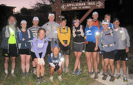
2010 starters
See also: The Quad State From Long Ago
The Course
Sun and Moon Data for One Day
U.S. Naval Observatory
Astronomical Applications Department
Harpers Ferry, Jefferson County, WV (Longitude W 77° 44', Latitude N 39° 19')
Saturday, October 19, 2019 Eastern Daylight Time
Sun
Begin civil twilight 6:57 a.m.
Sunrise 7:25 a.m.
Sun transit 12:56 p.m.
Sunset 6:27 p.m.
End civil twilight 6:54 p.m.
Moon
Moonrise 9:45 p.m. on preceding day
Moon transit5:17 a.m.
Moonset12:53 p.m.
Moonrise 10:35 p.m.
Closest Primary Moon Phase: Last Quarter on October 21, 2019 at 8:39 a.m. (local daylight time)
Phase of the Moon on October 19, 2019: Waning Gibbous with 70% of the Moon's visible disk illuminated.
|
|
|---|
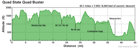
Course profile with Aid Stations Marked(credit: Keith Knipling)
Course Map
