The Big Schloss 50K
September 26, 2020
Start time: 7:30 a.m.
2019 RESULTS
The Big Schloss 50k race is hosted by Levi Mason and Cara Foley, under the sponsorship of the Virginia Happy Trails Running Club, and is held each year in late September. This challenging, Fat Ass style event, is run within the George Washington National Forest on the West Virginia side of the Virginia border, south of Wardensville, West Virginia and west of Woodstock, Virginia.
Entry will open sometime in August. A link to the online signup will be posted on this site. We have a limit of 55 runners.
There is no entry fee. Instead, it is hoped that you will make the time to volunteer to help maintain the trails that make up the Big Schloss course. In 2019, an organized trailwork day was held on Saturday, September 7 in conjunction with PATC's Stonewall Brigade. Following a few hours of trail maintenance, all adjourned to Ridge Runner Farm Brewery for refreshments. Please help us give back to the trails we love! Check the VHTRC's website or this page in 2020 for more details on possible work trips
In the typical VHTRC Fat Ass race tradition, we will also have you bring aid to contribute. You will receive an email the week of the race detailing what item to bring for the common aid.
Course Description
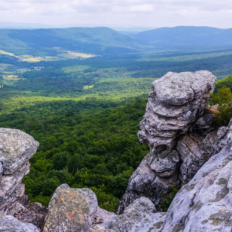
The course is a single clockwise loop around the Trout Run Valley, with a mix of singletrack trails and some dirt roads. There are three aid stations. The highlight is the ascent of Big Schloss about 2/3 of the way into the loop, with panoramic 360° views of the surrounding ridges and valleys.
The run starts and ends at Picnic Pavilion A in the Trout Pond Recreation Area. At the finish we will be grilling brats, burgers and vegan fare for everyone, so plan to stick around after the run to cheer on your fellow finishers and to just enjoy what will hopefully be a fine fall afternoon in the mountains. It's also a tradition to camp out and socialize after hours. Trout Pond campground is right next door. Reserve your spot ASAP when you sign up for the race to ensure you will have a place on site on both Friday and Saturday nights.
Finally, if you are not planning to run but still want to spend the day in these beautiful mountains, your help as a volunteer would be most welcome! Please email us if you're interested in volunteering at either the trail work day or race day.

Click image to enlarge
Resources - print these!
Video of Big Schloss 50K 2009 by Marc Raimondi
Cut-Offs
You have 10 1/2 hours to complete the race. Cutoffs are as follows:
Aid Station 1 (Mile 8.0) 9:50 a.m. (2 hours and 20 minutes)
Aid Station 2 (Mile 18.0) 1:30 p.m. (6 hours)
Aid Station 3 (Mile 23.8) 3:45 p.m. (8 hours and 15 minutes)
To receive an official finish in the final results, you then need to cross the finish line on the threshold of Pavilion A by 6:00 p.m. (10 hours and 30 minutes)
Club Event Participant Medical Policy
This is an event with very real risks to your well-being. The VHTRC does not provide medical care for runners at this event. Runners are responsible for their own health, safety, and well being at this event.
No doctors, nurses, or emergency medical technicians, or anyone with any medical training are available along the course, at any aid station, or at the finish. The club does not supply any medical goods or services, including bandages, splints, antiseptic, Ibuprofen or any other drugs to maintain the health of runners. Physical, medical, and emergency care is the runners' responsibility.
In case of an emergency, we will endeavor to get local emergency personnel to an injured runner as soon as possible. Since most of our events are in remote areas, medical care may be far away in distance or time.
Each year, runners finish — or are forced to drop out — with scrapes, deep cuts, hematomas, dislocations, and sprains. Runners have experienced cuts, bruises, bee stings, and asthma attacks. This is an event with very real risks.
Driving Directions
WARNING: OBEY speed limits everywhere in West Virginia, especially in Wardensville.
Directions from the DC area
- I–66 west to where it ends at I–81.
- Take I–81 South (left exit from I–66) for 4 miles to exit 296, Rt. 55 West.
- Take Rt. 55 west 18 miles to Wardensville, WV.
- In Wardensville, make a left turn at a stop sign at the intersection with Rt. 259 (at a used car dealer) to remain on Rt. 55. (WATCH SPEED). Pass a Liberty Gas station on the left.
- Left at the “Garrett Insurance” sign on the left onto Trout Run Road, CR23/10.
- Follow Trout Run Road for 5.4 miles to the intersection with Thorny Bottom Road.
- Turn right onto Thorny Bottom Road.
- Follow Thorny Bottom Road for 6.2 miles to the entrance for Trout Pond.
- Turn left into park.
- Follow the Trout Pond access road for about a mile to the entrance station.
- The road forks.
- Take the left fork (which may involve passing the entrance station and turning left) if you want to go to the Start.
- The right fork goes to the campground.
Alternate Directions from Woodstock, VA
There is a Wal-Mart located in Woodstock exit at Route 81 for any last minute supplies. This route adds about 20 minutes to your drive.
- West on 66 to South on Route I–81.
- Go about 13 miles and Exit at Woodstock, take a right at the top of the ramp to head West. The Walmart will be a couple hundred yards up the road on your left.
- From Woodstock, take VA 42 west for 5.3 miles to Columbia Furnace.
- Turn Right on Union Church Road (there may or may not be a sign - but there is a church and cemetery there) for a .10 of a mile
- Turn Left on Rt. 623 Back Road for .20 of a mile.
- Turn Right onto SR 675, Wolf Gap Rd, for 3.0 more miles. Bear right where the road appears to swing left to remain on Wolf Gap Rd. There might be a small sign here indicating Wolf Gap Road.
- Go exactly 10.0 more miles, climbing a winding, narrow, paved road with blind curves, crossing the mountain at Wolf Gap Recreation Area, and descending the west side (now WV) on a winding, narrow, paved road with blind curves. You will see a brown sign signaling an upcoming left turn for Trout Pond.
- Turn left onto the road to Trout Pond, paved, curvy at first. This is CR 16, Thorny Bottom Rd, but there are no signs that say so.
- Go 6.2 miles on CR 16. A sign on the left announces the Trout Pond Recreation Area. Turn left onto a paved entrance road.
- Go over a mile to the entrance station.
If you want to plug an address into a search service, Trout Pond Recreation Area, Trout Pond Campground Road, Lost City, WV will bring you into the campground and adjacent to the starting location at Pavilion A near the lake.
